|
|
Post by Herman on May 8, 2015 23:21:50 GMT
Perhaps Mark can answer this one. Did a flight on FSX into Duneden NZ. south island. Was wondering if this is an accurate representation of the scenery in terms of landscape. To me it seems that it is quite barren and semi-desert like with the odd bit of greenery. 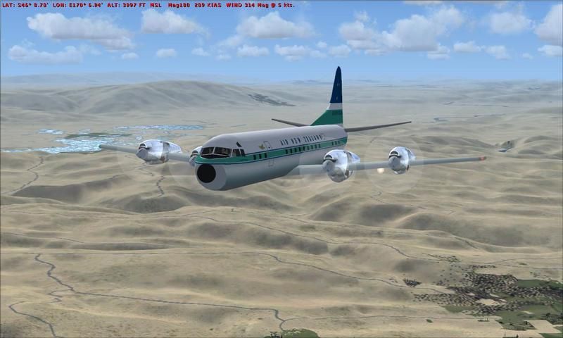 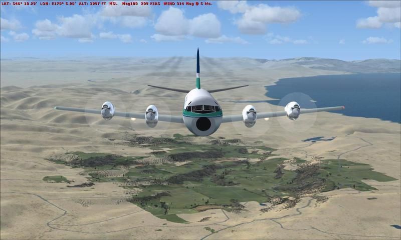 Herman |
|
|
|
Post by aerofoto - HJG Admin on May 9, 2015 21:10:30 GMT
Sorry Herman .... I've been at a pilots reunion and just caught up with this now/today  I'm not familiar with the Dunedin area in reality .... since I've never been there .... Dunedin being a different island (South Island) from me, in Auckland, in the north (North Island), and with "quite some distance separating the two "IF" .... you're using the default FSX supplied terrain for New Zealand, then, it will most certailny be "hopelessly wrong/inadequate" (as it has been the case for New Zealand scenery within every other previously released MSFS version .... New zealand, in FS, is not high priority region) .... so .... on the basis of the imagery you've provided, and your own suspicions too, I'd say your judgement is right .... that what you're seeing, in FSX, is neither good or authentic. It's not a case of just the mesh terrain being hopelessly inaccurate, but rather, it's a case of the land class texturing apearing completely inaccurate too (New Zealand is a "very green" country year-round) .... meaning nothing looks right in default FS terms terms and in regard to the colour of its geographic relief. So far as I'm aware .... there's never been an add-on mesh terrain scenery upgrade for New Zealand released for FSX. At SIMBIATION.COM .... there is such a package labelled as "FSX compativle", but, let me assure you .... having seen it for myself .... it "IS NOT" .... and featurex some major display problems. There "IS" a very good .... and "VERY AUTHENTIC" 20 meter mersh terrain scenery upgrade for the entirety of New Zealand, but, it's FS2004 compatible only .... and is'nt freeware  .... and .... it "IS NOT " cheap either .... unfortunately. Mark C AKL/NZ |
|
|
|
Post by aerofoto - HJG Admin on May 9, 2015 21:26:34 GMT
Herman .... If you'd like to refer to the following link ..... which I presented 3 years ago .... then you'll see not only see evidence of (1) the FS2004 20 meter NZ mesh terrain for the South Island .... and (2) the correct seasonal colours for the country .... aas well as also being able to see "a little" of how it actually looks in reality per the accompanying AIR NEW ZEALAND B737-300 AKL/CHC flight recorded by my brother and which is located at the very start of the above-linked thread .... tonymadgehjg.proboards.com/thread/5733/akl-b737-video-shot-yesterday#page=2As you (if you) follow this particular thread in its entirety, then, "DISREGARD COMPLETELY" my original comments in regard to the stated FSX compatible scenery version .... since as I discovered, only after presenting this thread, "the said" FSX advertised scenery upgade appears to be nothing more than a "rip-off" of the FS2004 version and which is not/has not ever been properly recompiled for FSX use .... "TRUST ME"  You should find what's ptresented (within the above link) "INTERESTING" non-the-less though Mark C AKL/NZ |
|
|
|
Post by aerofoto - HJG Admin on May 10, 2015 0:51:26 GMT
Herman .... further to your interest and observations concerning Dunedin, New Zealand, in FSX. Dunendin .... the area within which the airport is situated at least .... is (kind of) located within a bowl, on flat elevated plain between coastal hills to its eastern/Pcific side .... and again towards it nothern, western/inland, and southern extremetities, but, which isn't a particyularly large aerea. An extensive porton of the region .... en route toward Dunedin from Christchurch (to its north) .... and which extends north towards the inland and seaward Kaikoura muuntain ranges, westwards towards the foothils of the sOuthern Alps, and eastward to the Port hills (which border the east limits of Christchurch ....separate it from the port of Lyttleton), and then as south towards the Southern Lakes district and Denedin, is, indeed, a large expanse of "flat plain" .... but .... which is also composed of extensive and very green pasture land and which is not a bit desert-like in appearance. As I indicated within my first reply posting .... a combination of inaccurate mesh terrain .... then land class "in particular" .... tyically account for what you're currently seeing in FSX. "IF" I get time (although I very much doubt I will at the moment) .... I might try to prepare some imagery just to demonstrate the relief/geography of this region using my "very accurate" 20 meter mesh terrain and selected land class .... BUT .... we'll see how we go OK Mark C AKL/NZ |
|
|
|
Post by Herman on May 10, 2015 1:42:43 GMT
OK... thank you Mark for your replies and detailed (as usual) explanation.
It occurred to me just now that when I did the flight from Wellington to Dunedin the flight is done in Northern Hemosphere time of May 8th.( late Spring) I had forgotten that now in the SH it is late Fall. I guess FS does not automatically adjust for that difference???
When I did a short flight around Dunedin in your late December it did make a difference in that the ground was somewhat green. However there was still an absence of trees which perhaps is natural for that area.
I did another short flight here were I live (Victoria, South Vancouver Island)and the scenery and Topography looks fairly accurate.
Herman
|
|
|
|
Post by aerofoto - HJG Admin on May 10, 2015 3:45:39 GMT
Unless you've got decent Land Class files .... to cover, and detail, even the default mesh terrain you're (apparently) using, then it probably won't make much difference Herman .... because without it (decent Land Class detailing) one season is still going to look about as bland as the next M$ .... "ALWAYS" .... detailed specific FS geographic areas at the expence of the detailing for others. New Zealand isn't as significant as other parts of the world, so, it's never had the attention. Have a look at the default Milford Sound scenery "as suplied by M$ in any version of FS" .... THEN .... compare it with the Milford Sound scenery within the link I've provied, among 2 or 3 other NZ regions, 3 postings back on this same thread. This particular recreation of Milford Sound represents the enhanced 20 meter mesh terrain add-on version .... further enhanced by the apropriate Land Class detailing too ..... the combined effect of which make for a "HUGE DIFFERENCE" and a virtual experience which is "PRETTY/RECOGNIZEABLY ACCUTATE". Mark C AKL/NZ |
|
|
|
Post by Herman on May 10, 2015 15:58:56 GMT
Sorry Mark, but I did not realize that this particular topic had previously been covered in such great detail.
I have now located the thread you are referring to and will check for available sceneries on the freewarescenery.com website etc.
Herman
|
|
|
|
Post by hornit - HJG on May 10, 2015 21:38:11 GMT
I will say ONE WORD to you...... ORBX |
|
|
|
Post by Herman on May 10, 2015 23:45:28 GMT
OK hornit....thanks for your suggestion.
Herman
|
|
|
|
Post by aerofoto - HJG Admin on May 11, 2015 1:46:42 GMT
I was trying to get this up yesterday, but, didn't have time Herman .... This should give you (everyone) some impression of the type sscenery/terrain associated with the route you recently overflew using the default FSX supplied mesh .... although admittedly the VOR to VOR route I selected results in a track more toward the SSW, then SSE (a bit of a dogs leg), using both Christchurch and Mount Mary VOR's en route toward Dunedin (the scenic route) .... rather than opting for your (what must have been Herman's) almost contant line of bearing between Christchurch and Dunedin (the inland coastal route). The scenery depicted below repreents the payware 20 New Zealand meter mesh terrain enhancement by Christian STOCK aka "THE RED BARON" .... for FS2004 .... unfortunately it's not FSX compatible. In my particular case this scenery has been enhanced using both the land class supplied with it .... as well as that provided per Lennart ARVISSON's FS2004 scenery/land class upgrade, both Perfect Sky and Perfect Water scenery enhancements, Feng ZOUH's (I think his name is) trees, along with another addon forrest scenery texture (I can't remember the name of it) too. None of these files are new .... and the (general) quality of what I'm using may well have been surpassed with more recent/superior options, by now, but, living here (most of the time) as I do, I still think "these particular files" make my FS scenery .... "for New Zealand" (at least) .... look as it should. Here's a few scenes following a similar routev to Herman .... At 3,500 FT ..... roughly half way across the Canturbury Plains between Christchurch and Mount Mary VOR's (115.30 and 112.50 respectively) .... and tracking the 225* radial (total distance of around 100 miles DME) .... most of this region is a broad flat-land located on the eastern side of the Southern Alps and which is punctuated by pastures and a number of river systems which drain from the mountains (in the west) toward the open sea on the South Islands eastern/Pacific Coast .... 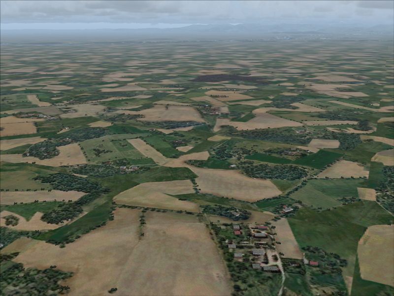 Continuing roughly SSW .... along the 225* radio between both Christchurch and Mount Mary VOR's .... and approaching the SW extremety of the Canturbury Plains near the Peel Forrest Park and foot hills of the McKenzie high country .... I was eventually forced to climb to around 6,000 FT in order to be able safely navigate over (rather than into) the hilly terrain visible ahead of me .... 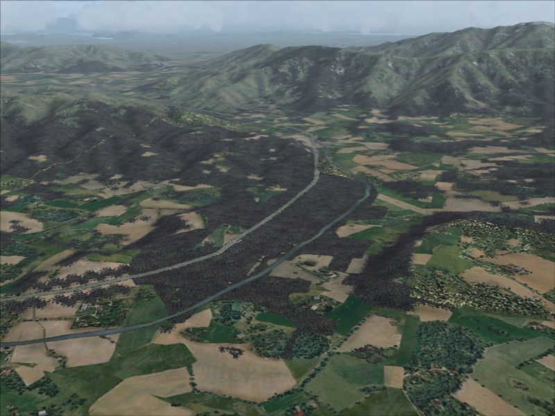 Having passed the Mount Mary VOR .... continuing at around 6,000 FT .... but on a new track (now) of approximately 147* between Mount Mary and Swampy VOR's (112.50 and 112.70 respectively) .... and weaving between the Kakanui Mountains and Rock And Pillar Ranges (total distance of around 88 miles DME) toward Dunedin .... 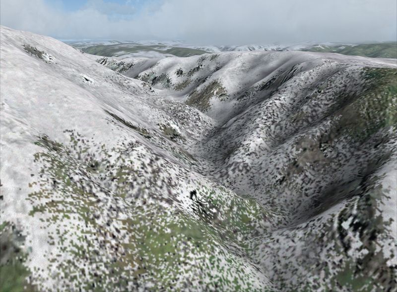 Back down to around 3,500 FT and continuing roughly SSE toward the Otago Gold Fields Park and Dunedin .... backgrounded by the Pacific Ocean on the east coast of New Zealands South Island .... 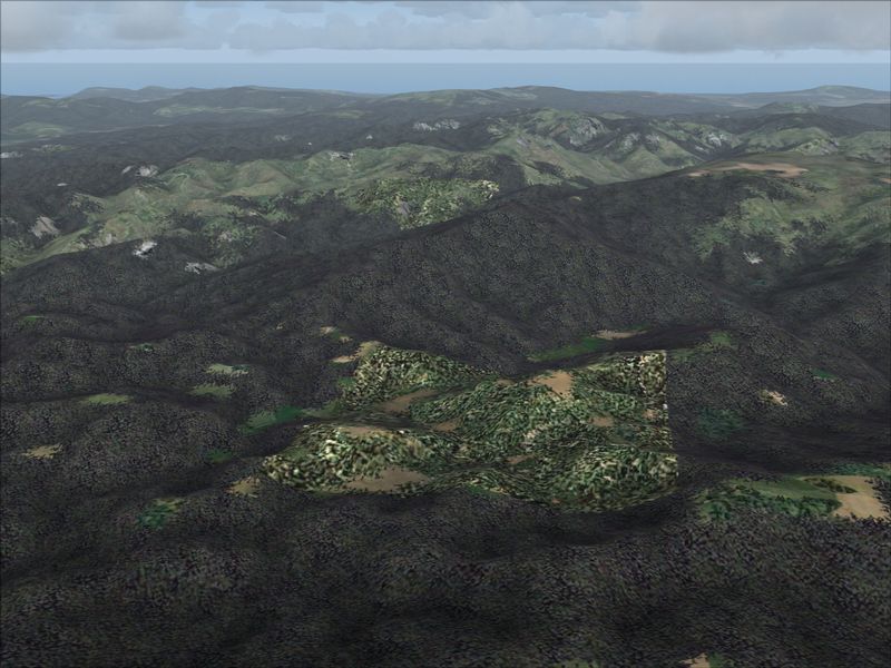 Dunedins neibouring town of Mosgiel (to the west of the city) .... with Taiere Aerodrome visible within the lower right quarter of this particular view .... Dunedin Airport is siutuated further to the south oo this flat-land region (the Taiere Plains) between the coastal and inland hill country and ahead of the 2 lakes just visible within the upper middle section of this particular scene .... 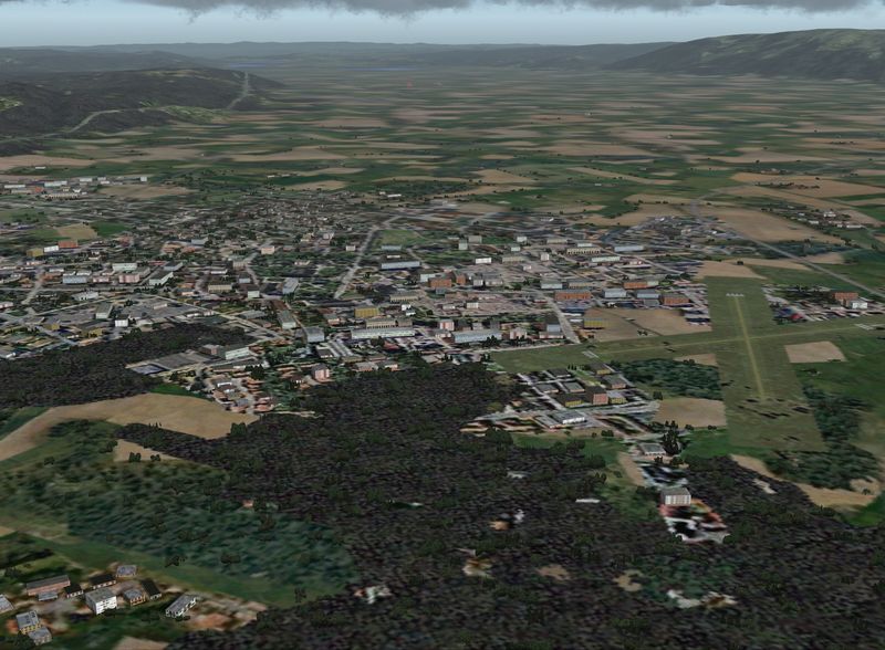 The approach to Dunedin Airports RWY 03 .... over the Taiere Plains and from the south and toward Mogiel .... 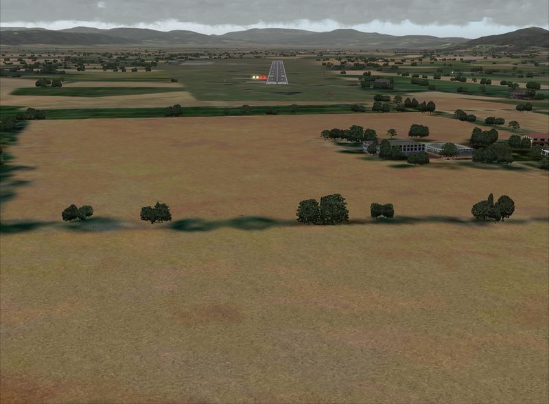 The City of Dunedin and Otago Harbour with Port Chalmers .... and the Otago Peninsula .... 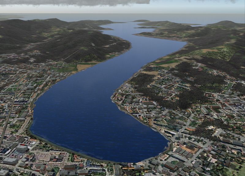 The entrance to Dunedins Otago Harbour and Port Chalmers .... with Taiaroa Head and the Otago Peninsula located to the left .... and Heyward Point and Aromoana situated to the right .... 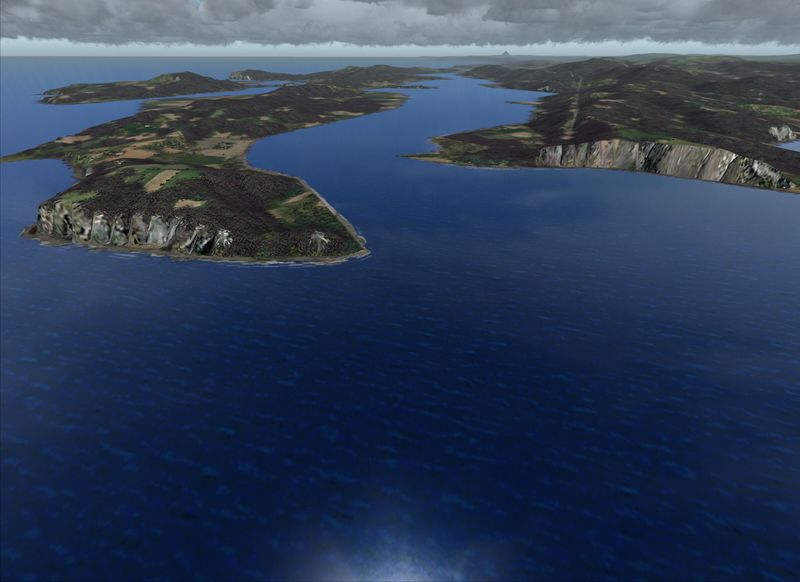 As can hopefully be seen/appreciated .... some diverse "and green" (all year-round) scenery .... which is quite a bit different from M$'s default interpretation/representation of this particular region of New Zealands beautiful South Island. Mark C AKL/NZ |
|
|
|
Post by Herman on May 11, 2015 6:27:28 GMT
Thank you Mark for taking the time to post these images. What a huge difference from the stock FS default scenery.
I had a look also on Google Map and it certainly confirms and agrees with your findings that New Zealand is indeed quite Green.
Herman
|
|
|
|
Post by aerofoto - HJG Admin on May 11, 2015 8:44:27 GMT
"VERY" green .... throughout each of the 4 seasons .... a severe dumping of winter snow promoting the only exception to this particular rule Mark C AKL/NZ |
|


 .... and .... it "IS NOT " cheap either

